

Top Sunrise Photo Spots in Sedona
For Sedona sunrise viewpoints, choose spots that match your tolerance for early starts and crowds. Arrive 30–75 minutes before official sunrise to capture pre-dawn color and calmer conditions.
Doe Mountain — quick mesa sunrise with 360° views
Why go: Short, steep approach to a flat mesa gives wide, layered vistas ideal for sunrise panoramas and foreground silhouettes.
Parking & access: Small trailhead lot off Dry Creek Road. Trail is roughly 1.5 miles round-trip; plan 30–45 minutes to the top depending on pace. Lots can fill on weekends—arrive early.
Best months & timing: Works year-round; fall and winter often give longer, cooler golden-hour light, while summer sunrises are much earlier.
Difficulty: Moderate (steep switchbacks to mesa top).
Sedona photography tips (sunrise/sunset): Bring a headlamp for pre-dawn hiking and a compact tripod for low-light stability.
Safety: Watch edges on the mesa and carry water for early starts.
Devil’s Bridge — iconic arch for sunrise silhouettes
Why go: The sandstone arch creates a strong silhouette against morning skies; the approaches give elevated valley views beyond the bridge.
Parking & access: Use Mescal or Dry Creek trailheads. Round-trip distances vary (~1.8–3.8 miles depending on your start). Parking is limited at sunrise—plan arrival 60–90 minutes early or consider a shuttle where available.
Best months & timing: Cooler months draw photographers for sunrise light; summer sunrises come very early, so plan accordingly.
Difficulty: Moderate — some slickrock scrambling near the arch.
Crowds & Devil's Bridge sunrise parking: Expect lines on the bridge; be courteous and allow shared compositions.
Leave no trace: Stay on the trail and respect signage around the arch.
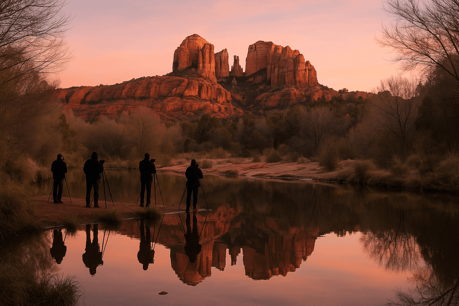
Crescent Moon Ranch / Cathedral Rock — creekfront sunrise reflections
Why go: Oak Creek reflections of Cathedral Rock are a classic Sedona sunrise photo when pools of water are present; lower-angle light softens textures.
Parking & access: Crescent Moon Ranch (Red Rock Crossing) is a USFS-managed area with a modest lot and short walks to creek viewpoints. Parking fills for golden hour—arrive early when reflections are desired.
Best months & timing: Best after recent rains or during seasons when creek pools form—often fall through spring for stronger reflections.
Difficulty: Easy — mainly flat paths to creekside viewpoints.
Phone tip: Low vantage points near the water strengthen reflections; use HDR if needed.
Respect park rules and posted hours at Crescent Moon Ranch.
Top Sunset Photo Spots in Sedona
Sunset photo spots Sedona-wide vary by crowd tolerance and parking. Pick a site early, know lot sizes, and plan for a short walk back in the dark.
Airport Mesa (Airport Scenic Overlook) — classic panoramic sunset
Why go: Elevated panoramic vistas make Airport Mesa a go-to for dramatic wide-angle sunsets and local portraits against the red-rock skyline.
Parking & access: Small parking area off Airport Road with a short walk via Sedona View Trail to the overlook. The lot frequently fills at sunset—plan to arrive 45–90 minutes early on busy evenings.
Best months & timing: Good year-round; fall and winter often yield crisp, saturated sunsets.
Difficulty: Easy — short walk from lot to overlook; some uneven ground.
Airport Mesa sunset Sedona: Very popular for sunset; consider weekdays or shoulder seasons to avoid peak crowds.
Safety: Stay away from cliff edges and bring a flashlight for the walk back.
Red Rock Scenic Byway pullouts — flexible sunset framing
Why go: Pullouts along State Route 179 / Red Rock Loop Road give quick access to views of Bell Rock and Courthouse Butte—useful when you want multiple compositions without long hikes.
Parking & access: Pullout sizes vary; some offer only a few spaces. Check signage—some nearby trailheads require a Red Rock Pass.
Best months & timing: Afternoon into sunset; broken-cloud evenings often create dramatic shafts of light around the buttes.
Difficulty: Easy — roadside stops or very short walks to better foregrounds.
Composition tip: Use telephoto to compress layers or a wide lens for dramatic foreground-to-background depth.
Combine stops: Park at a pullout and walk short trails for alternative foregrounds.
Chapel of the Holy Cross — architectural framing at golden hour
Why go: The chapel set into the red rock offers framed landscape-and-architecture shots with minimal hiking.
Parking & access: Visitor parking is limited with a short paved walk to the viewpoint—check chapel hours before planning a visit during operating hours.
Best months & timing: Late afternoon through sunset works well; spring and fall are comfortable for walking and shooting.
Difficulty: Easy — paved access to the viewpoint though ground near overlooks can be uneven.
Respect: Remain on public paths and follow any chapel visitor rules.
Composition tip: Frame the chapel against ridgelines for layered images at golden hour.

Practical Access, Rules & Safety for Sunrise/Sunset Shoots
Local rules, parking, and safety practices are essential for a smooth shoot. Conditions and restrictions can change—check local official sources before you go.
Parking, Red Rock Passes & lot sizes
Red Rock Pass and parking rules: Many trailheads and some pullouts in the Red Rock / State Route 179 corridor require a Red Rock Pass or paid parking; rules may change seasonally. Display any required pass visibly if a lot signs a fee.
Lot sizes & timing: Airport Mesa, Crescent Moon Ranch, and the main Devil’s Bridge lots are small and often fill for golden hours. Arrive 45–90 minutes early at peak times or use nearby less-crowded viewpoints.
Check current conditions with the Coconino National Forest or posted signage before arrival.
If lots are full, park legally in designated areas or choose an alternate viewpoint rather than creating unsafe parking.
Shuttle services or guided transport can ease Devil’s Bridge parking worries during busy periods.
Trails, accessibility & seasonal cautions
Trail difficulty & distances: Top spots range from paved, low-walk viewpoints (Chapel of the Holy Cross, some pullouts) to steeper hikes (Doe Mountain, Devil’s Bridge). Match your site to your fitness and daylight.
Seasonal conditions: Forest Service roads like Schnebly Hill Road may require high-clearance 4WD or be seasonally closed—check notices. Storms can make slickrock, pooled water, or short washouts.
Accessibility: Airport Scenic Overlook and Chapel area are better for limited mobility, but nearby terrain can still be uneven.
Bring a headlamp or flashlight for pre-dawn or post-sunset walking and dress in layers for temperature swings.
Wear sturdy shoes; even short routes can include loose rock.
If a road requires 4WD, do not attempt it with a standard vehicle—follow Forest Service guidance.
Drones, permits, and low-light safety
Drones & permits: Drone use is restricted across many public lands near Sedona and on tribal lands; commercial work usually needs permits. If you plan to fly, check federal, Forest Service, and tribal rules—assume drones are not allowed unless explicitly permitted.
Personal safety and courtesy: Low-light shoots increase fall risk, navigation errors, and limited cell coverage. Keep group members together, use lights on trails, and respect other visitors and wildlife.
Respect private property: Some viewpoints border private land—do not cross fences or posted boundaries to get a shot.
If unsure about drone rules at a location, assume they are restricted.
Keep noise low and minimize disturbance; pack out all trash and equipment accessories.
Carry water, a basic first-aid kit, and a portable phone charger for longer outings.
Amazon Products to Make Your Trip Better


Sunrise-to-Sunset One-Day Itinerary (Photo Stops + Uptown Shopping)
A practical day plan that links Sedona sunrise viewpoints with Uptown Sedona stops—coffee, galleries, and Mi Amore Sedona at the historic Hart Store—then finishes at a sunset overlook.
Suggested timeline: Sunrise to sunset
Pre-dawn to morning: Choose Doe Mountain for a quick panoramic sunrise or Devil’s Bridge for arch silhouettes. Aim to arrive 45–75 minutes before sunrise; bring a headlamp for the trail in darkness.
Morning & late morning: Return to Uptown Sedona for coffee and an easy stroll. Use this time to review images, swap batteries, and plan your afternoon scout.
Afternoon into sunset: Scout Red Rock Scenic Byway pullouts or Bell Rock in the late afternoon. Finish at Airport Mesa for a classic sunset overlook or at Red Rock Crossing (Crescent Moon Ranch) for Cathedral Rock reflections if creek conditions allow.
Timing: Allow midday for lunch, gear checks, and a relaxed visit to the Chapel of the Holy Cross or other low-walk sites.
Buffer: Build in extra time for parking and walking—lots near hotspots fill faster than expected.
Where to shop & recharge: Uptown Sedona and Mi Amore Sedona
Why stop here: Uptown Sedona is the town’s main shopping area for galleries, outfitters, and cafés. Mi Amore Sedona, inside the historic Hart Store on Main Street, is a convenient place to find local gifts and keepsakes after a day of shooting.
Timing tip: Visit Mi Amore Sedona in the late morning or early afternoon to avoid the busiest shopping window and to secure purchases before heading back out for sunset.
Uptown parking: Public lots and street parking are available but can get busy—use earlier hours for easier parking.
Image care: Use a midday stop to swap batteries, back up memory cards, and top up any gear before the evening shoot.
Quick camera & phone tips for Sedona sunrises and sunsets
Keep gear visitor-friendly: use a compact tripod for stability, a headlamp for early/late walking, and weather-appropriate layers. Avoid heavy setups if your plan includes hikes.
Phone-specific tips: Use grid lines, lock exposure on the brightest/darkest area as needed, and stabilize the phone with a small tripod or stable surface for long exposures.
Arrive early: Capture the sky before and after the sun crosses the horizon for better color ranges.
Bracketing: Take multiple exposures for high-dynamic-range scenes if your camera supports it; use phone HDR when appropriate.
Backup: Copy cards or upload images during midday breaks in Uptown to reduce risk of data loss.

Planning your Sedona visit? Here are answers to common questions about shopping in Sedona and finding meaningful Arizona gifts at Mi Amore Sedona. We look forward to welcoming you in.